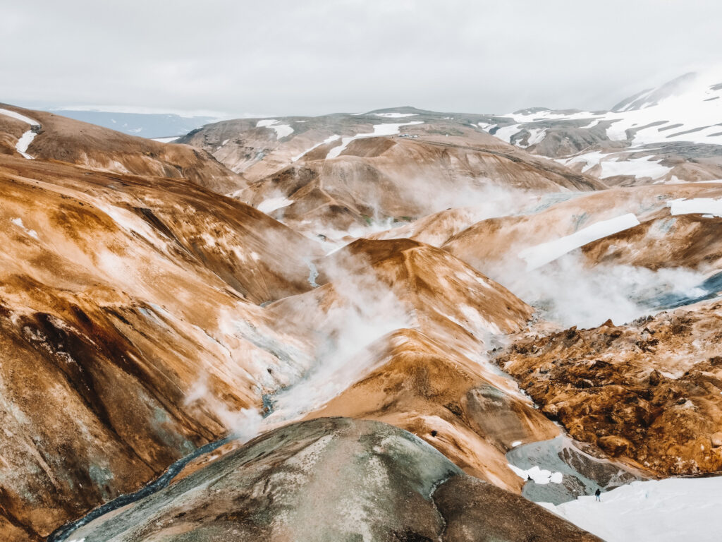
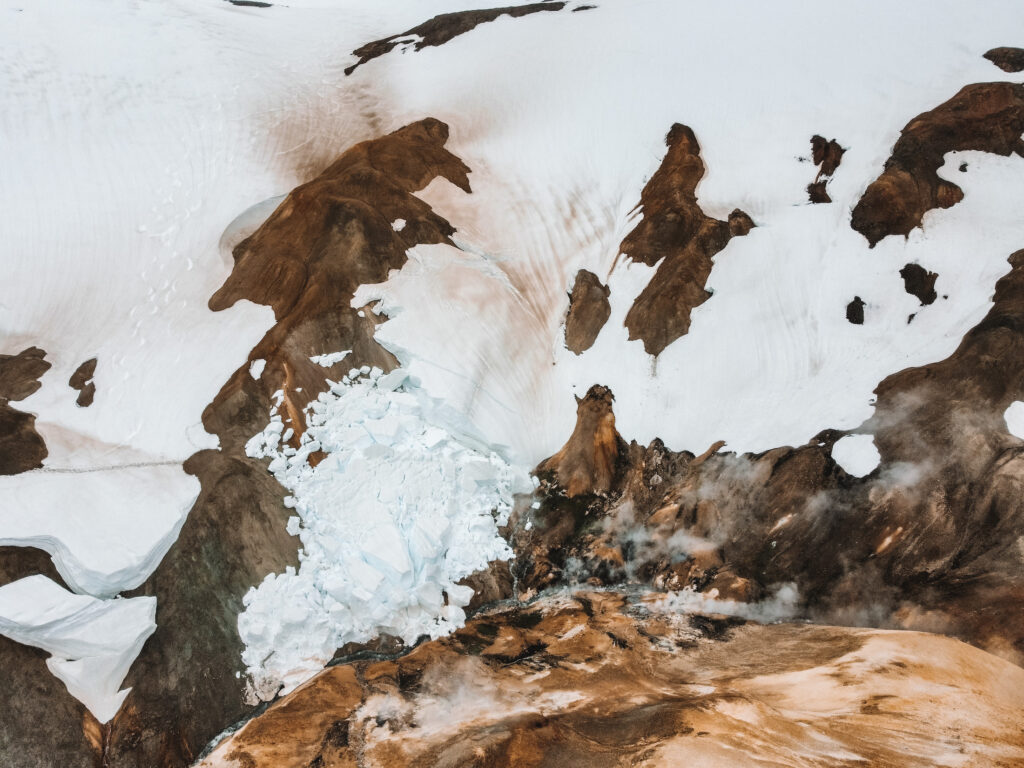
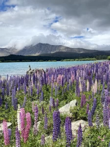
I’m not kidding when I say Kerlingarfjöll is the most unique place I’ve ever been. Before my solo trip to Iceland in June, I saw pictures of it online and knew I needed to make a trip there myself. The rolling hills, colorful clay deposits, and constant steam feel closer to outer space than anywhere else on Earth.
Here is a complete guide to day tripping Kerlingarfjöll and the Hveradalir Geothermic Area, including logistical details and the best things to do once you get there!
Disclosure: Some of the links below are affiliate links. When you purchase through links on my site, I may make a small commission (at no extra cost to you!).
What is Kerlingarfjöll?
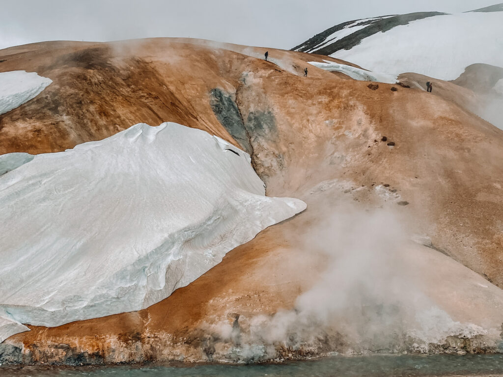
Kerlingarfjöll is one of Iceland’s most incredible natural wonders. The 1,477 m (4,846 ft) tall mountain range forms a part of a large tuya volcano system, a rare type of volcano that forms when lava erupts through glacier or ice. The Kerlingarfjöll mountain range is also home to some of Iceland’s most impressive geothermal activity, with numerous hot springs and a steaming geothermal valley.
Kerlingarfjöll is located in the Highlands of Iceland, an area in the middle of the country that is sparsely inhabited and made up of volcanic desert. While most tourists stick to driving the Ring Road or the Golden Circle, the Icelandic Highlands make an awesome detour for the adventurous traveler.
The name Kerlingarfjöll is made up of two words: Kerling, meaning old lady and Fjöll, meaning mountains. Legend has it that an old troll was walking around the mountains when the sun came up and turned her to stone. According to Icelandic folk tales, the trolls that live in these mountains only travel at night now so they don’t suffer the same fate!
How to get to Kerlingarfjöll
By car
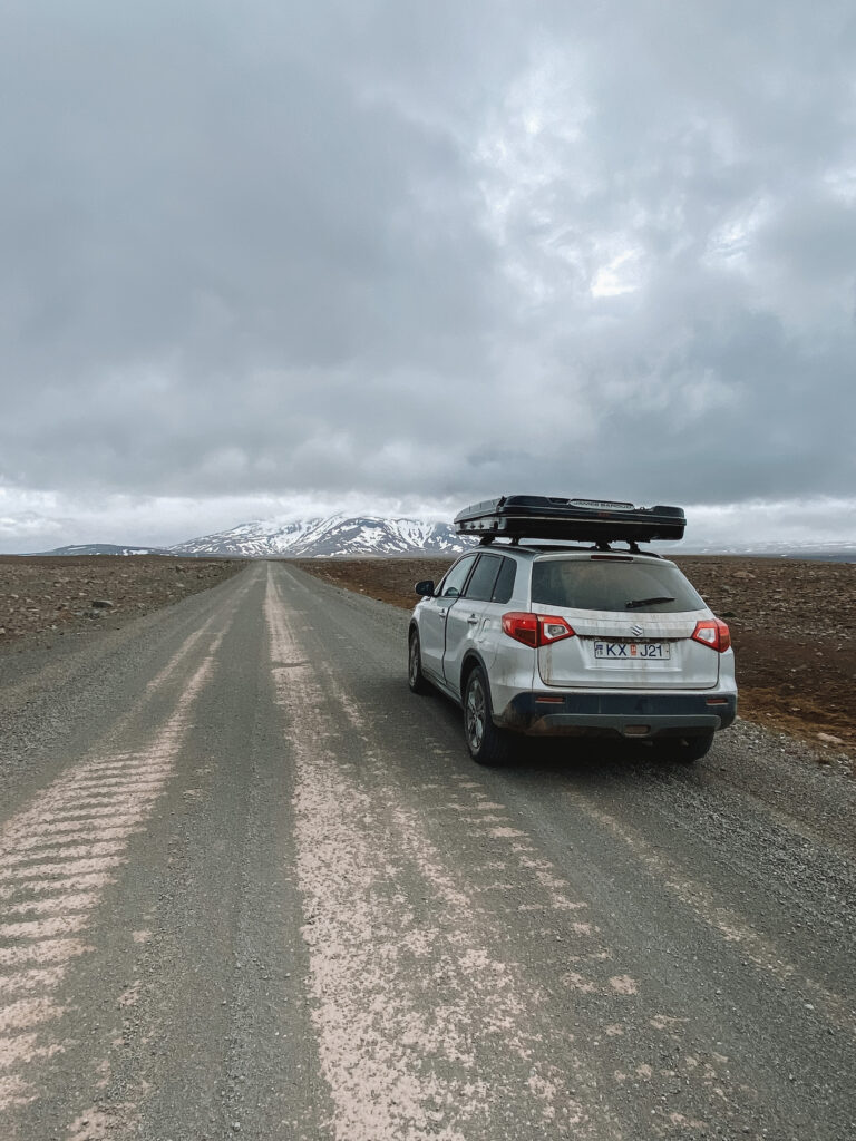
Driving yourself is the simplest way to reach the Kerlingarfjöll area. There is one road leading to and from Kerlingarfjöll: F-35, also known as the Kjölur Route. This highland road stretches from Svínavatn Lake in the north of Iceland to Gullfoss Falls in southern Iceland’s Golden Circle.
Like all of Iceland’s F-roads, you’ll need a 4×4 vehicle to drive to Kerlingarfjöll (a 2WD rental car won’t cut it). F-roads are remote, unpaved, and can sometimes include river crossings or massive potholes. They are often closed in the winter and can be hit by bad weather very suddenly.
That being said, the F-35 is probably the most well-maintained F-road in Iceland. From the south, the road is largely smooth gravel with several uneven dips and curves. The last 5 km (3 mi) or so are extremely bumpy and mostly uphill — the deeper into Iceland’s central highlands you go, the rougher the road gets!
Keep in mind that there are no petrol stations or supermarkets within the mountains of Kerlingarfjöll. Make sure to have some snacks, water, and a full tank of gas before you set out.
From Reykjavik, the drive takes about 3 and a half hours. You’ll follow Route 35 towards Gullfoss Waterfall, which then turns into F-35 heading north towards Kerlingarfjöll.
From Akureyri, Iceland’s “Capital of the North,” the drive will take around 5 and a half hours. You’ll follow the Ring Road (Route 1) towards Reykjavik for 118 km (73 mi) before turning south down the F-35.
⇉ Everything You Need to Know About Driving in Iceland: A Road Trip Guide
By bus
If you’re not renting a car on your trip to Iceland, there is a coach bus service to Kerlingarfjöll that runs during the summer months.
The Gray Line Iceland bus runs from Reykjavik to Hveravellir natural hot spring with a stop at Kerlingarfjöll Mountain Resort. Buses run on Mondays, Wednesdays, Fridays, and Sundays between mid-June and early September. Tickets can be booked online in advance.
Take a tour
Booking a guided day trip is another good way to visit Kerlingarfjöll if you want somebody else to take care of all of the logistics.
Tours are available from several different companies with transfers from Reykjavik, Gullfoss, or Akureyri. The Viator tour from Akureyri listed below is expensive, but it has great reviews and takes you to both Kerlingarfjöll and Hveravellir hot springs.
When to visit
The best time to visit Kerlingarfjöll is from late June to early September. This is considered the summer season and is the only time of year that you’re able to go hiking. During the summer months, you’re also more likely to catch some (relatively rare) good weather in the Hveradalir geothermal area.
The F-35 road leading to Kerlingarfjöll usually opens sometime in June and stays open through autumn. When I visited in June 2022, I actually had to change my itinerary around because the road was still closed due to heavy snows in late spring! You can check the status of the road and its expected opening date on the Road.is website (look for Kjalvegur, 35).
If you want to visit Kerlingarfjöll in the winter, you’ll need to join a guided tour — the road is closed to independent travelers. Because of the unpredictable and unstable weather, road conditions change quickly and it’s definitely better to leave the driving to a professional. Popular winter activities at Kerlingarfjöll include snowshoeing, snowmobiling, and bathing in the natural hot springs.
Where to stay near Kerlingarfjöll
The one and only place to stay within the geothermal area of Hveradalir is Kerlingarfjöll Mountain Resort.
There, you’ll find a variety of accommodation options, including double rooms in mountain huts, chalets, and a camping site with space for tents and caravans. Kerlingarfjöll Mountain Resort is currently being renovated and is slated to reopen in summer 2023.
If you don’t want to stay at the highland resort, I’d recommend staying at Skjól Camping near Gullfoss Falls. The campsite was clean, quiet, and has an on-site restaurant that makes great pizza.
Things to do at Kerlingarfjöll
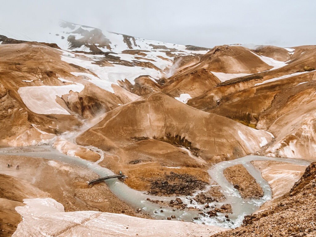
Hveradalir Geothermal Area
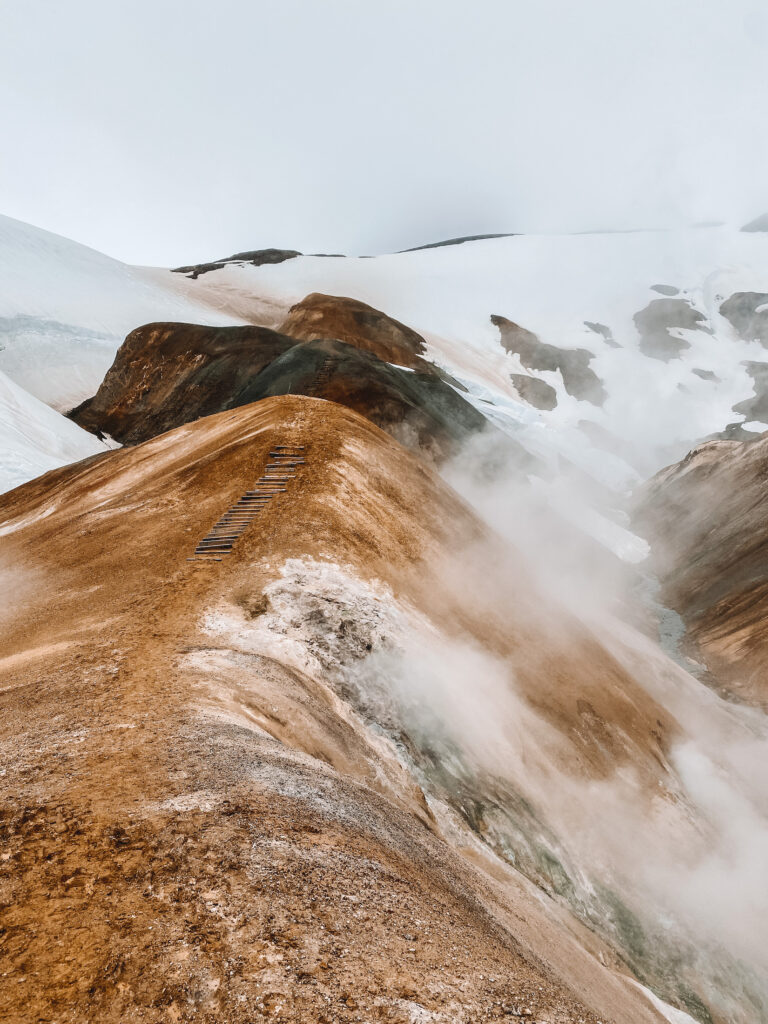
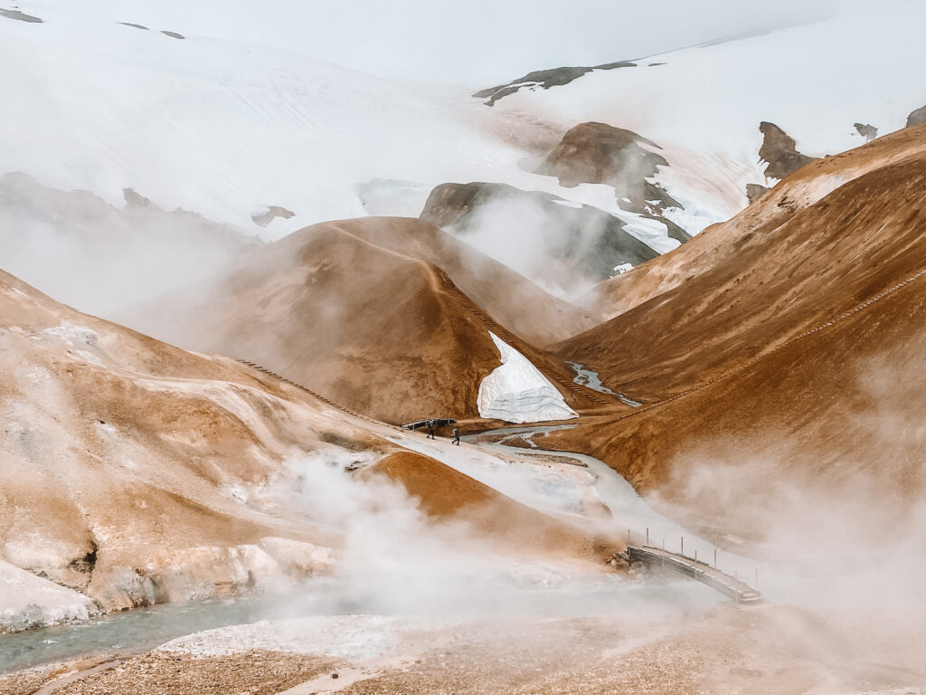
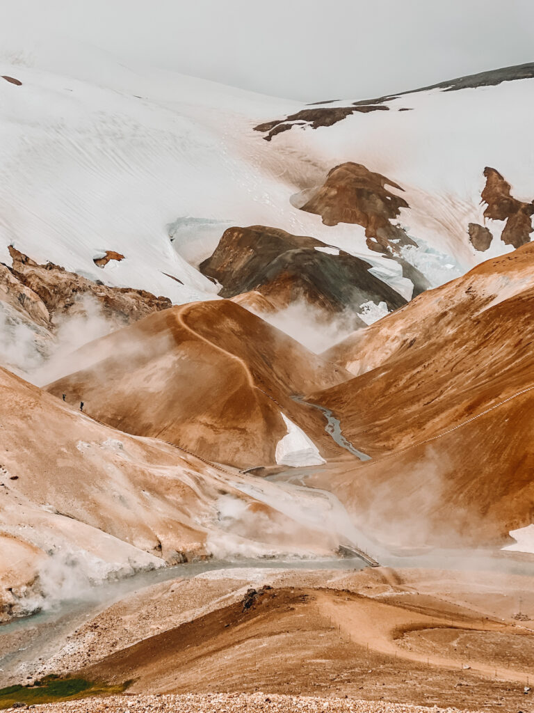
The Hveradalir Geothermal Area is the most popular thing to do at Kerlingarfjöll and is a definite must-see. This is where you’ll find a wide area filled with springs, steam vents, rivers, and tracks. There are over 3 km (2 mi) of hiking trails that crisscross around the valley — I’d allocate at least 2 hours to wandering up and down several hills to get different views.
Hveradalir Geothermal Area can be reached by driving to the Keis car park, about 3 km (2 mi) past Kerlingarfjöll Mountain Resort (search for 4×4 Parking Geothermal area on Google Maps). Once you get there, it’s a short downhill walk over some precarious wooden steps to get to the valley floor.
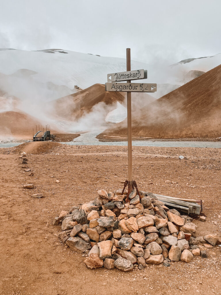
Kerlingarfjöll Hot Spring
The Kerlingarfjöll hot spring was created accidentally after a failed attempt at drilling for hot water in the Asgarður Gorge. It’s located about 1.5 km (0.9 mi) from the Kerlingarfjöll Mountain Resort and can be found by following a short trail along a river. The pool itself can fit up to 15 people and has a temperature ranging between 34-37°C (93-98°F).
Like other rural Icelandic hot pools, the Kerlingarfjöll hot spring does not have a changing room (or any facilities, really). It might be worth it to bring a dry bag to keep your clothing and electronics dry.
Trailing the peaks (Austurfjöll)
Total distance: 7 km (4.3 mi)
Duration: 5 to 6 hours
This challenging short hike summits three surrounding mountains: Fannborg, Loðmundur, and Snækollur, the highest peak at Kerlingarfjöll at 1,428 m (4,685 ft). The track begins from the Kastali house parking lot and continues up and down each subsequent summit. Although this hike isn’t for the faint of heart, it is the perfect place to score some unmatched views of the Hveradalir area.
Check out some more Iceland posts!
Reykjavik travel guideVik travel guide
How much I spent in Iceland
Golden Circle itinerary
Everything you need to know about driving in Iceland
The Circle Route
Total distance: 47 km (29 mi)
Duration: 3 days
The Circle Route is a moderately challenging multi-day trek through remote Icelandic wilderness. It traverses a small valley, an area with volcanic activity, and several rivers and streams. There are two huts, the Klakkur and the Kisubotnar, that offer shelter along the way. This hike would be great for anyone that loves undisturbed wilderness, as you probably won’t see a single soul once you get past a certain point.
Practice your photography
Kerlingarfjöll is a photographer’s dream — the otherworldly landscapes and painted-on appearance make for super dramatic photos (even as an amateur!). One of the best things to do while visiting is to soak in the scenery and take lots of pictures.
A quick note on flying drones: be very wary about the strong wind that blows between the Kerlingarfjöll mountains! I flew my DJI Mini 2 and it nearly got swept away, never to be seen again. Keep a close eye on your drone and land it quickly if it seems to be struggling with the wind.
Kerlingarfjöll packing list
- Wind breaker: An outer layer specifically to block wind will help protect against the intense gusts
- Warm clothing: Think wool base layers, thick hiking socks, and a down puffer jacket
- Sleeping bag: In case you’re camping and need a warm place to sleep
- Beanie: To keep your ears warm
- Portable charger: A travel essential
- Swimsuit: For the Kerlingarfjöll hot springs
- Reusable water bottle: Iceland has extremely fresh and pure water — don’t even think about buying plastic bottles!
- Sunscreen: Although Iceland isn’t always sunny, the sun’s UV rays can still cause damage
- Hiking poles: A game-changer when you’re hiking up and down the steep and squishy clay ground
Things to know before visiting Kerlingarfjöll
- You’ll notice a very strong rotten egg smell once getting to the Hveradalir geothermal area parking lot. This comes from the deposits of sulphur, iron, and other minerals present in the thermal vents!
- For the entire day trip to Kerlingarfjöll, including driving to and from Gullfoss, wandering Hveradalir geothermal area, and soaking in the hot springs, allow at least 10 hours.
- Check the weather conditions before heading out. If there is extremely inclement weather, especially on the Kjölur road to and from Kerlingarfjöll, try to postpone your trip until the weather clears. The F-35 road is the last place you’d want to get stuck in a storm! Vedur is a reliable website to use to check the forecast in Iceland.
- Always leave with a full tank of fuel because there are no gas stations along the way. I used nearly half a tank driving from Gullfoss to Kerlingarfjöll and back.
- Make sure to have your rental company’s breakdown phone number handy when you drive. It’s also a good idea to save all of your travel insurance documents within easy reach.
- Certain areas within the Icelandic highlands don’t get any phone reception. Save a map of the area offline to your Google Maps app so you don’t get lost.
You’ll also love:
- The Ultimate 3-Week South Island New Zealand Road Trip Itinerary
- Hiking Flattop Mountain: Alaska’s Most Popular Peak
- Balkans Road Trip Itinerary: 2 Epic Weeks Down the Adriatic Coast
Thanks for reading this guide on how to visit Kerlingarfjöll!
xoxo Niki

Thank you very much for this informative blog post! This will be really helpful when planning my trip to Iceland this September. I was wondering if you need any permission for flying a drone (Dji mini 3 pro) in Kerlingarfjöll or if there have been any drone restrictions in this area? I would be really grateful if you could share your experiences with me.
Best, F
Hey Franziska, thanks for your nice words!
There were no rules against flying drones at Kerlingarfjoll when I went last June. When you get there, double check that there aren’t any “No Drone Zone” signs in the area. It is super windy there as well, so just make sure that your drone can handle it! My DJI Mini was almost swept away, haha.
Have fun!